
Technology
Revolutionizing 3D Mapping: DJI’s Latest Software Takes Flight

Drones Beyond Cinematography
When we think of drones, high-flying visuals and thrilling races often come to mind. Yet, DJI, a leader in the drone industry, is pushing boundaries far beyond the silver screen. With applications ranging from photogrammetry to civic planning, DJI’s drones are proving to be versatile tools in professional sectors. Their commitment to enterprise solutions is evident through a dedicated website featuring specialized drones, attachments, and software tailored for industrial use.
Terra and Modify: A Dynamic Duo
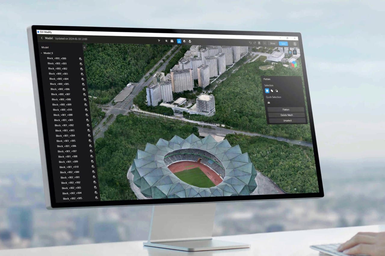
In 2019, DJI introduced Terra, a powerful 3D mapping software designed to transform visual data into detailed 3D models for a variety of planning and analytic purposes. But DJI didn’t stop there. Their latest software, Modify, elevates the game for cinematographers and creatives alike. This free-to-use editing tool allows users to refine 3D-mapped data, removing unwanted objects and artifacts to create flawless 3D scans. The implications for the movie industry and beyond are significant, as this technology ushers in a new era of precision and efficiency.
Editing Made Easy with Modify
Modify is seamlessly integrated with Terra to provide a suite of impressive editing capabilities. From correcting errors caused by reflective surfaces to removing random objects captured inadvertently, Modify simplifies the post-scanning process. It’s not just about fixing the obvious mistakes; Modify’s clever tools and AI assistance can tackle the subtler issues of photogrammetry, such as removing artifacts that can clutter scans and repairing broken surfaces with ease.
Smart Auto-Repair Tools at Your Fingertips
DJI Modify isn’t just another editing software; it’s a smart solution that brings a host of intelligent auto-repair tools. Whether it’s flattening uneven surfaces, editing textures, or regenerating damaged patterns, Modify’s AI-driven tools handle it all. The software’s one-click repair feature, alongside manual customization options, provides unparalleled control over the editing process. Plus, its model display technology allows for simultaneous high- and low-quality model editing, making the workflow smoother and more intuitive.
Compatibility and Future Cloud-Sharing
Modify supports various file formats, ensuring it works hand-in-hand not only with DJI Terra but also with other third-party software. Looking ahead, DJI plans to introduce cloud-sharing capabilities, which will allow users to easily share their processed 3D models online without the need for additional software installations.
Professional Applications and Public Beta Access
Targeted at professionals across multiple sectors, DJI Modify is poised to enhance operations in transportation, urban planning, public safety, and more. Its robust model editing features are ideal for a wide array of drone surveying applications, including architecture, engineering, construction, and emergency response. Currently available as a free Public Beta, this revolutionary software can be accessed through DJI’s Enterprise website, inviting professionals to experience the future of 3D mapping and model editing.
Exploring the World of Design and Innovation
While DJI forges new paths in the drone and 3D mapping sphere, the world of design and innovation continues to thrive with unique and efficient solutions. From Japanese design philosophies to modern architectural marvels, the pursuit of excellence in product design is a journey of constant discovery and admiration. As we look to the future, we remain committed to showcasing the best in international product design and the endless possibilities it presents.

Hello! I’m Roger Jenkins, your go-to source at ReportingTheNews.com. I’m a USC graduate who combines journalistic precision with a Trojan’s passion. Based in sunny Los Angeles, my days are filled with more than just sunshine; they’re about capturing stories that resonate.
Beyond the newsroom, I’m an avid triathlete. Swimming, cycling, and running are more than just sports to me; they embody my commitment to discipline, focus, and a healthy dose of competition.
My love for travel takes me far and wide. Guadalajara, with its vibrant culture and unforgettable tacos, has a special place in my heart. I’m always searching for the next great story or a hidden culinary treasure.
At home, Nala, my energetic pet, is my constant companion. Together, we’re known in our neighborhood for our morning runs and evening strolls.
I’m driven by a belief in the power of storytelling to unite communities. Join me as we explore impactful narratives and stay updated with the latest news. You’ll also get a peek into my sports passions and travel escapades.
Want to get in touch? Follow me on Instagram for more insights and updates.